Article on Saltwire by Carole Morris-Underhill, March 21 2022. Click here for original article.
Council to take outing to site in question
WINDSOR, N.S. It appears West Hants councillors will soon be taking a field trip to get a better understanding of Fort Edward National Historic Site’s view planes.
A special council meeting was held March 16 to discuss the recently released Phase 1 archaeological report, as well as other background information, pertaining to municipally-owned lands located adjacent to the Parks Canada property.
“I do find that since we’ve been having more discussions on the future of this site, I’ve been receiving quite a few supportive comments to go a historical route,” said Coun. Laurie Murley as the meeting began.
“It’s been quite overwhelming actually, over the last, I’ll say, probably two weeks.”
During the pandemic, West Hants Regional Municipality began looking to sell off surplus properties. Windsor’s former Centennial Swimming Pool, which had been demolished in 2019, and the adjacent parking lot were among them. The municipally-owned lots of land – located at 36 and 65 Fort Edward St. – are adjacent to Fort Edward National Historic Site, located at 67 Fort Edward St.
They were listed for sale in 2021 for $303,000. Around the same time as council gave the CAO direction to enter into a sale’s agreement for the property, the municipality started a rezoning process to change the designation from open space (community) to R2 (residential).
That’s when a community-led movement to halt West Hants from rezoning the lands and selling it to a developer began.
Community members – including those involved with the West Hants Historical Society – would like to see the property retained for public use and a museum or interpretation centre built in order to better promote the historic value of the site. Not only would it be educational, but it would increase tourism, which would in turn boost the local economy.
Jonathan Fowler, of Northeast Archaeological Research, presented a Phase 1 archaeological resource impact assessment to council on March 8, 2022.
Fowler’s report outlined key historical facts about the fort, which was built in 1750 on the ruins of an Acadian church.
Coun. Jim Ivey said he thought Fowler’s report provided exceptional detail and was quite informative. He said he wished they had the information a year prior.
“As somebody once said to me, ‘we are where we are so what do we do now?'” said Ivey.
He proposed council determine the cost associated with carrying out a Phase 2 archaeological study and the time frame that it would take to have one completed.
Coun. Murley, Coun. Jeff Hartt and Mayor Abraham Zebian all spoke favourably about pursuing more information.
“I would hate to see any history lost here,” said Hartt.
After an in-camera council session, the CAO was tasked to bring to the March 22 council meeting a report that details a Phase 2 archaeological assessment of 36 and 65 Fort Edward St.
View planes ‘vitally important’
Absent from the meeting was a representative from Parks Canada. Mark Phillips, the chief administrative officer, said they declined council’s offer to provide comments in a public forum “due to jurisdictional awareness, with this land being municipal land.â€
However, he said he sought clarity on a few issues, including that of view planes. He said while it’s open to interpretation, the primary view plane, as described to him, was “a 10 o’clock through to a 2 o’clock view plane that needs to be respected versus a 6, 7, or 8 o’clock, which kind of brings it further back towards Lake Pisiquid.”
Ivey, who frequently shoots photos throughout Windsor and West Hants, was one of the councillors concerned about how the view planes could be impacted if the municipal property was sold and developed.
“I’ve been up there a lot and I’ve shot the fort from many, many different angles,” he said.
Ivey noted that the site was selected due to its vantage point, allowing troops to see the enemy approaching by both land and sea. The hill currently offers a panoramic view, looking out at the Avon River towards the Minas Basin. One can also view the highway, heading towards St. Croix, as well as Lake Pisiquid and the upper reaches of the Avon River.
“So, when they talk about the approach of enemy forces, I have no idea which enemy they were talking about at the time as to whether, in fact, it was the French or the Mi’kmaq or any other group that may have been coming,” said Ivey.
He noted the view planes at Citadel Hill, a historic landmark in Halifax that was built during the same time period, have been “greatly chipped away at” since the 1970s due to high rise buildings.
“That fort is there because of the view planes and Windsor was established because of the fort being there,” said Ivey. “View plane is vitally important.”
Deputy Mayor Paul Morton suggested council go on a field trip after Coun. Ed Sherman asked for a photo that would better illustrate the 10-2 view plane.
“We’re going to be talking about this for another six, eight, 10 meetings, probably, in my educated guess. Why don’t we set a time before our meeting and go up there and have a look?” said Morton.
After some discussion, the mayor said staff would organize an outing.
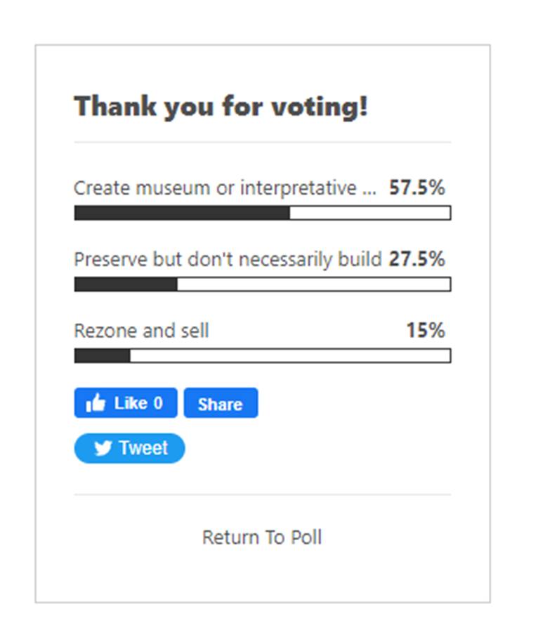
What should be done with the land adjacent to Fort Edward?
The original article continues with an online poll asking readers to vote between four options. Results of this poll and the following image were shared on the “Stop the Rezoning of Fort Edward” facebook group: “Results of the reader poll on the article published this week in Saltwire’s Atlantic edition. 85% of readers against rezoning and selling the property to a developer.”